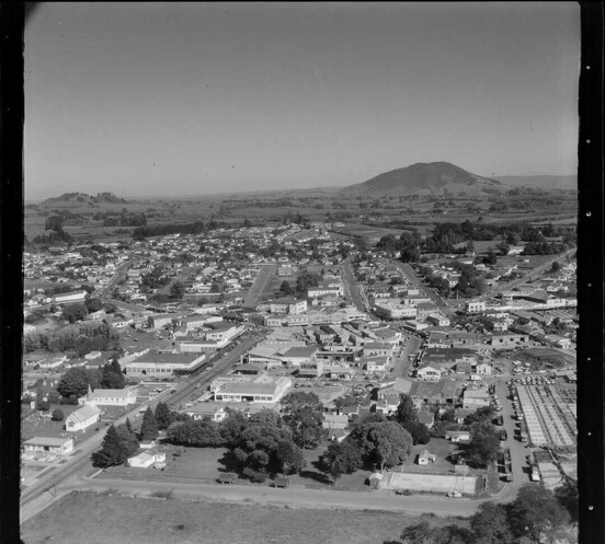
Te Awamutu, Waikato, with Kakepuku on the horizon. Whites Aviation Ltd: Photographs. Ref: WA-60045-F. Alexander Turnbull Library, Wellington, New Zealand. /records/22905603
Te Awamutu History
Documented Te Awamutu history stretches back to the fourteenth century, when Tainui landed at Kawhia and settled the area. It was home to the Otawhao Mission and St John's Church which was erected in the 1850's and still stands today. The Battle of Ōrākau, one of the most significant battles in the New Zealand Wars, was about 3.5km south of the town near Kihikihi. Read a detailed account of Te Awamutu history below.
Early Te Awamutu History
Tainui Maori first settled the Waikato area as early as the fourteenth Century. Traditionally their forebears sailed to New Zealand from Hawaikii. The Tainui canoe is buried at Kawhia and it was from there that the people consolidated and gradually spread, settling most of the Waikato and the King Country. It was a good area for settlement, with excellent growing conditions and river access. Many pa were established in Te Awamutu and districts area due to these favourable conditions.
From 1775 to approximately 1810 a number of prominent Waikato chiefs and warriors were born. This included the first Maori King, Potatau Te Wherowhero of Ngati Mahuta, Te Rauparaha of Ngati Toa, Kawhia, and Hongi Hika, a Ngapuhi Chief from the north, who played a significant role in Waikato history.
It was Hongi Hika who invaded the Waipa triangle in 1822 at Matakitaki near Pirongia. The site of Matakitaki Pa and its inhabitants were well suited to traditional Maori hand-to-hand conflict but were defeated by the musket. This was the first time that European weaponry was used in the Waikato. The battle at Matakitaki Pa was where the musket overcame the taiaha.
Waikato leaders were quick to appreciate the value of the musket in battle and traders began appearing amongst the Maori people exchanging muskets for flax. This was the first contact between Waikato Maori and the Europeans.
The introduction of the musket resulted in a period of intense tribal warfare. In 1834 missionaries visited the district bringing about a change in the Maori way of life. By the 1840's after intervention from Wesleyan, Church of England and Catholic missionaries there was peace.
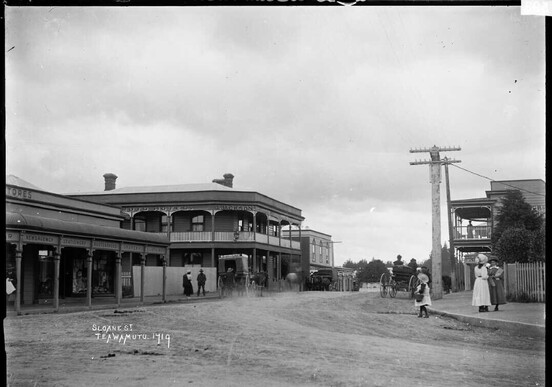
The name Te Awamutu refers to the end of the river; the Manga-o-hoi stream. Canoes could navigate the Manga-o-hoi stream as far as Te Awamutu and from then travel had to be overland.
At Te Awamutu were two important Pa. Otawhao, a pa on the hill which is currently Wallace Terrace and Kaipaka Pa which is to be found at the end of what is now Christie Avenue.
Otawhao, named after the Tainui tupuna Tawhao, was the first visited by missionaries in 1834. It was at Otawhao Pa that the first church is recorded in1838 and where in 1839 Reverend Ashwell asked the Whare Kura (Christian Maori) to leave and set up a separate community at "Awamutu". It was this act which led to the establishment of the Otawhao Mission station.
Under the directorship of John Morgan, who resided at the Otawhao Mission with his wife Maria from January 1841 until 1863, personal contributions to the history of the area were made in the fields of religion, education and agriculture. During these years there was a significant increase in the agricultural work undertaken by Maori in the Te Awamutu and districts area. This included the establishment of a number of flour mills which were largely funded by Maori parishioners. The resulting crops and produce supplied, amongst other places, the Auckland markets.
Old St. John's Church
During this period, at the request of the parishioners, permanent church buildings were erected: St. John's (1854) at Te Awamutu and St. Paul's (1856) at Hairini (Rangiaowhia).
The mission buildings were leased by the New Zealand Government in 1862 and John Gorst as Civil Commissioner of the Waikato took over the Otawhao Mission School. From within the mission site the printing press "Te Pihoihoi Mokemoke" began printing, in Maori, opinion which opposed that of the King Movement paper "Te Hokioi". In March 1863 Ngati Maniapoto seized the government press and only after negotiation returned it onto the Queen's land at Te Ia. The seizure was one of many factors which led to the expulsion of Europeans from Te Awamutu and districts and the outbreak of the Waikato Wars (1863-1865).
In 1864 the Otawhao Mission Station became the Headquarters for the army of General Cameron.
At the conclusion of the Waikato Wars ex-militia and settlers became the first Europeans to populate Te Awamutu. This was followed by the opening up of European settlement to the area with the railway in 1880, and the further development of the economy through farming, especially dairying.
The sale in 1907 of the Otawhao Mission Farm, which consisted of 173 acres, signalled the growth of the town of Te Awamutu.
Te Awamutu is presently a town of around 10,000 people. It functions as a rural service town and comes under the Waipa District Council.
Te Awamutu has taken the rose as a symbol, and is the self-proclaimed Rose Capital of New Zealand. It is an area of great historical interest, with old churches, pa sites, redoubt sites and battlegrounds nearby.
O-Rãkau -
The New Zealand Wars
Ōrākau is located approximately 3.5 km south-east of Kihikihi on the Arapuni Road. There is a memorial obelisk here in a small reserve that overlooks the battle ground on the side of the road. In the future it is the intention of the Orakau Heritage Society Inc to build a historic site and visitors learning centre to tell the story of this great battle and to provide a place for the sacrifices of those who fought and fell at Ōrākau to be respected.
Battle of Ōrākau - 31 March - 2 April 1864
This was a 3 day engagement and probably the best known of the New Zealand Land Wars. It inspired two films called Rewi's Last Stand. At the conclusion of the battle the Kingitanga Maori retreated into the rugged centre of the North Island and about 12,000sq km were confiscated by the crown.
After the battle at Hairini (February 1864), in March Tūhoe and Ngāti Raukawa warriors determined to fight, arrived from the east to support the Ngāti Maniapoto forces.
Rewi Maniapoto did not want to fight, especially at this location. "Only by not fighting may I retain my lands … do not fight at Ōrākau". He warned that "if you Tuhoe persist in your desire for battle, I alone will be the survivor". It was to no avail and many of his supporters joined Tūhoe and Ngāti Raukawa in urging him to make a stand. After trying to buy some time by suggesting consultation with Wiremu Tāmihana at Maungatautari, Rewi gave in and decided to fight at Ōrākau.
In late March Rewi's men began building a redoubt shaped pa at Ōrākau, which was noticed by the British that were stationed nearby in Kihikihi. An armed force under Majors Von Tempsky and Blyth were sent to investigate. At this stage there were only approximately 300 Maori defenders and a third of these were women.
The fortified pa, which was situated in a peach grove lacked a good supply of water and escape route and Rewi's fear of it being easily surrounded proved to be its undoing.
When the British advance began, they were able to hold off an attack of four abreast, however when the British were hit by a second volley they decided to surround the pa. Maori reinforcements were prevented from reaching Ōrākau by steady fire from the British forces and thought all would perish in the pa. On April 2nd, Lieutenant - General Cameron arrived with reinforcements that bolstered the British Troops to over 1400. At this point the defenders at Ōrākau were almost out of food, water and ammunition, even resorting to using peach stones and wood pellets as bullets. In spite of their desperation when they were offered a last chance to surrender they replied with the now famous reply, one version being:
"E hoa, ka whawhai tonu matou, Ake Ake Ake! Friend, we will fight on forever, forever, forever!"
It is not known for certain who said these words but the intent was clear and this helped to lay the idea that Ōrākau was a "last stand" for Maori.
Despite holding back two more assaults at 3.30pm nearly all the Maori left the pa in an orderly fashion and caught the British Troops by surprise. They split into small groups and attempted to escape. Pursued by Cavalry and Forest Rangers through open lands between Ōrākau and the Puniu River most of the Maori casualties were suffered at this time. It is estimated that at least 160 were killed, with many including women being bayoneted as they lay wounded. The British by contrast only suffered 17 dead and 50 wounded.
Some historians see this as a victory to Cameron, however the King Movement still existed, now South of the Puniu River - the new aukati (boundary) in Ngati Manipoto. Tamihana and Rewi Manipoto warned the British that if they attempted to continue the war beyond the aukati they would fight again. The British did not fight here again and moved their attention to Tauranga and the Bay of Plenty to prevent supplies and reinforcements coming to the aid of the Kingitanga.
Old St John's Church: A Brief History
By Jim Mandeno, QSM
In January 1841 Rev. John Morgan was appointed to the Otawhao Mission which occupied the present day Selwyn Park opposite St. John's. Here an earlier church was built in 1842. A commodious place of worship. By 1850, encouraged by his Maori parishioners who offered to donate timber and finance, Morgan appealed to the Church Missionary Society for funds. By 1852, still without money, he reports that the sawing of timber had commenced. He achieved his goal when on Easter Day 1854 the church was opened for Divine Worship, Archdeacon Abraham travelling from Auckland for the occasion. It is of interest, that whilst erecting St. John's Morgan was also planning another of similar design at Rangiaowhia, now Hairini which was not completed until 1856.

Construction
The framing and weatherboards are of heart Matai, cut from Rangiaowhia and Kihikihi districts. The weatherboards are three hundred and five millimetres, rusticated construction with fillets at the corners. The lining is heart rimu, set vertically. All timber is pit sawn and the building erected by two European carpenters, Edwards and Chitham assisted by Maori helpers. The windows are of particular interest, constructed of timber frames with nullions of flat iron welded together. These were salvaged from the first mentioned church and were carried by the Maori people over the Wairere track from Tauranga, an ancient trail over mountain, bush and rivers.
The Church Yard
Directly in front of New St. John's is a memorial to some of the Maori soldiers who died during the hostilities in the Land Wars. These were interred here at the request of Bishop Selwyn, first Anglican Bishop of New Zealand. The British casualties who died at the battles of Rangiaowhia, Hairini and Orakau are interred to the north of the church. In 1888 the government erected a memorial to the rank and file, who are interred close by. Two officer's graves can be seen directly outside the sanctuary, while nearby is the memorial to four of John Morgan's children. A tour of the Church Yard will also reveal the names of many pioneers of this district and whose descendants still reside and help preserve our historical heritage.
The Interior
Gracing the sanctuary is a magnificent stained glass window, possibly one of the oldest Victorian figurative painted and fired stained glass windows in New Zealand. It comprises of three lights, the left showing St. Peter's ship, the centre, the emblem I.H.S., the Last Supper at Emanaus, and in the right light, a church. Contrary to legend that it was donated by Queen Victoria, it is correct to state that this window came from St. John's Auckland. It was possibly executed by William Wailes (1850 - 1853).
Early in 1864, during the Waikato Land Wars, St. John's became a garrison church for the men of General Cameron's Army. To a Maori Chieftainess, Te Paea Potatau, who placed her mana on the church, do we owe it's preservation. Many other European buildings were burnt at that time. A number of wooden tablets, memorials to those who died during the fighting in this district were erected around the interior walls - only those in the baptistry have survived. Here also is a tribute written in Maori and English. A tribute from a British Regiment of Foot the 65th, "The Royal Tigers" who arrived in New Zealand in 1847 and did not depart until 1865. A regiment who had come to respect and were respected by their Maori opponents.
Other memorials are to be seen in the main body of the building, also memorials to honour the men of the district who made the supreme sacrifice during two world wars. Attention is also drawn to the footprints on the ceiling near the main door. Many are the legends told of their origin.
Map of the Waipa Delta, circa. 1864
This map was charted around 1864. The legend reads:
"A plan of the country between the Waikato and Waipa Rivers shewing the native redoubts at Piko Piko, Paterangi Orakau, Ahaupo & Maungatauteri occupied by Lt. Genl. Cameron C.B. during the months of January, February, March and April 1864"
Note that the map is upside down, i.e. north is at the bottom. The different versions show the full map of the Waipa Delta and a close-up showing Te Awamutu and Cambridge.


Extra Reading
For more information on the the Battle of Ōrākau and the New Zealand Wars visit:
www.orakau300.co.nz - The Battle of Ōrākau Heritage Society Inc
A more detailed account of the Battle of Ōrākau - www.nzhistory.net.nz/war/war-in-waikato/battle-of-orakau
The Waikato War - www.hamiltonwaikato.com/the-waikato-war - NZHPT in conjunction with HamiltonWaikato.com have created a phone app and downloadable resources relating to the key battle sites
www.teara.govt.nz/en/interactive/27087/invasion-of-waikato - Photo's, video's, old documents and much more from (or about) this time in history.
NZHistory.net.nz - New Zealand History online
www.teara.govt.nz/en/1966/maori-wars - An entry from the encyclopedia of New Zealand (1966), which indicates how the wars were thought about half a century ago
www.newzealandwars.co.nz - a site run by Danny Keenan, formerly Associate Professor of Māori Studies, Victoria University of Wellington
Stay connected
Enter your email to sign up for the Te Awamutu newsletter

Selected images courtesy of Te Awamutu Camera Club / Arthur Uden / Hamilton and Waikato Tourism / Bea Schiller

Destination Te Awamutu
Destination Te Awamutu is the official tourism website of Te Awamutu, Pirongia and Kihikihi. It is administered by the isite Te Awamutu.
Get in touch
Address: 1 Gorst Avenue, Te Awamutu 3800
Phone Contact: 07 871 3259
Email Address: consultant@teawamutuinfo.co.nz
Office Hours:
Monday: 9am - 5pm
Tuesday: 10am - 3pm
Wednesday: 10am - 3pm
Thursday: 9am - 5pm
Friday: 9am - 5pm
Weekends: CLOSED
Public Holidays: 9am - 5pm


